The UK’s new electoral map means fewer votes, many changed constituencies – and perhaps enhanced Conservative prospects for 2020
The boundary review process began last week following the publication of the electorate figures that the Boundary Commissions will use. Ron Johnston digests the numbers and looks ahead to the likely outcomes of the review. He suggests that, barring very large alterations in the patterns of party support, it is likely to enhance Conservative prospects in 2020.
An exercise to redraw the United Kingdom’s electoral map started on 24 February with publication of the number of people registered as electors on 1 December 2015. These figures determine the number of parliamentary constituencies allocated to each of the four countries and across England’s nine regions for the next general election (due in 2020), plus the size and nature of each constituency.
These allocations, and the subsequent redrawing of the map of individual constituencies, will use rules designed to ensure equality of representation across constituencies. They were introduced by the 2011 Parliamentary Voting System and Constituencies Act, which also fixed the number of constituencies at 600 (replacing the current 650). The Boundary Commissions’ initial implementation of those rules would have produced a new set of constituencies by October 2013, to be used for the 2015 general election. That exercise was halted by parliament in January 2013, however; it is now being restarted with no change to the rules.
The registered parliamentary electorate on 1 December 2015 was 44,722,004 – a decline of some 603,074 over the figure for the same date in 2014. Although some two million people who had not been registered by 1 December 2014 had done so in the run-up to the 2015 general election, many had clearly not re-registered when the annual canvass was held some five months later. In addition, the government’s decision to bring forward the switch to individual electoral registration at the end of 2015, rather than waiting for another year for registration officers to ensure that the roll was as complete and accurate as possible, meant that perhaps as many as 600,000 people who would otherwise have been retained on the register were removed. Research by the Electoral Commission and others suggests that many of those so excluded (plus many of those who registered for the 2015 election but did not then re-register later) are concentrated among the young (especially students), ethnic minorities, and flat-dwellers (mainly renters), who are concentrated in many of the country’s inner city areas. Their absence from the 1 December 2015 electoral roll will have had a significant – if difficult to establish with hard numbers – impact on the geography of constituency allocation. Basically, however, the cities – especially London – will probably get several fewer seats than otherwise might have been the case; many of the current constituencies with large student populations have experienced substantial declines.
The rules for redistribution set out in the 2011 Act require every constituency to have an electorate within five per cent of the national average (or quota). (There are four exceptions – the so-called ‘protected constituencies’: they are the current small constituencies of Na h-Eileanan an Iar and Orkney and Shetland in Scotland – with 2015 electorates of 20,887 and 33,229 respectively; and in England, the Isle of Wight – currently one constituency with 105,448 electors – is guaranteed two seats under the new rules.) The quota is 74,769 (the total electorate divided by 596), and so every constituency must have an electorate, using the 1 December 2015 figures, between 71,031 and 78,507.
The geographical impact
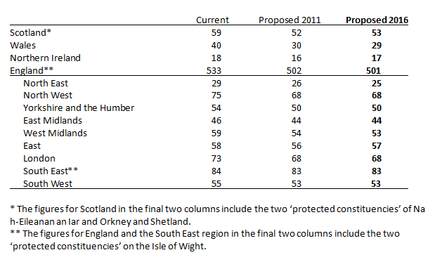
The first stage in the exercise involves allocating constituencies to the four countries, to ensure equality of representation. The four Boundary Commissions have undertaken that determination, with the outcome shown in the table below. England gets 501 seats – a decrease of 32 against its current number; Scotland gets 53 instead of the present 59; Wales has 29, instead of 40 as now; and Northern Ireland’s complement falls by just one – to 17.
Although the largest absolute loss of MPs will be from England, proportionally the largest is for Wales; there will be 27.5 per cent fewer Welsh MPs when the new parliament meets, compared to England’s loss of six per cent. Scottish MPs will be reduced by 10.2 per cent, and Northern Ireland’s by just 5.6 per cent.
This major change in Wales was not unexpected since, in terms of the ratio of electors to MPs, Wales has long been over-represented in the House of Commons: the average constituency there at the 2015 general election had 57,057 electors (English constituencies averaged 72,853). The decrease in the number of Welsh MPs is even greater than it would have been if the new rules had been fully implemented in 2011-13. The table’s final column shows that the allocations during that aborted exercise gave Wales 30 of the 600 constituencies. It has lost another seat since, as too has England because of changes in their electorates. Both Scotland and Northern Ireland have gained one.
For England, the 2011 Act recommends that constituencies be allocated according to the nine standard regions, with no constituency crossing a regional boundary. The Boundary Commission for England accepted that advice, which gives the allocation of seats shown in the lower section of the table. The largest reductions, compared to the current situation, are in the more urban regions – North West, West Midlands, London, Yorkshire and the Humber, and North East; the other four regions lose only one or two seats each.
The balance of representation within England when the new House of Commons is elected in 2020 will therefore swing towards the more rural, southern regions. Currently 54 per cent of England’s MPs are drawn from the three northern regions plus the West Midlands and London, and 37 per cent from the East, South East and South West; in 2020 those percentages will be 53 and 39 respectively – a switch of some 23 seats that could well benefit the Conservatives over their largest rival. Labour is also likely to be the major loser from the reduction of Welsh MPs – undoubtedly one reason why the party is accusing the Conservative government of gerrymandering.
One clear consequence of the changes in the number of constituencies and their allocation across the UK is that many current seats will disappear. Of those 646 (i.e. excluding the four protected constituencies) 398 have electorates below 71,031 and a further 49 have electorates larger than 78,507. All but six of the over-large seats are in England; all but one of the current Welsh seats are too small, as are 41 of Scotland’s and 13 of Northern Ireland’s. And although 149 of the current seats have electorates within the prescribed range it is very unlikely that many of them will remain unscathed – they may fit within the five per cent caliper but their neighbours may not, so all will have to be changed. For example, during the 2011-3 exercise, although 200 of the existing English constituencies had electorates within the caliper only 78 of them were entirely unchanged in the Boundary Commission’s provisional recommendations, with a further 77 remaining intact but with more electors allocated to them; thus 455 of the 533 seats were altered to some extent, many of them very substantially – and the same will undoubtedly be the case in the review that has just begun.
Although most of the current constituencies will be substantially changed, therefore, some of those that might have been introduced in 2011 may still fall within the prescribed limits and be used again; the commissions could use the maps they had ready in 2013 as the starting-point for this new exercise. This might be the case in some areas, but not others, however. Northern Ireland gets an extra seat this time, and to accommodate one more constituency many of the 16 that were to be recommended in 2013 will have to be changed; indeed, the whole of Northern Ireland’s 2011 map may have to be redrawn to accommodate what ostensibly would appear to be a small change. Similarly, the loss of a further seat each from Wales and three English regions could mean substantially redrawing many of the constituency boundaries there from those that had been prepared for the 2015 election.
Two additional issues may mean more extensive redrawing of constituency boundaries than some expect. Although it is not bound to make each constituency a group of contiguous local authority electoral wards, the Boundary Commission for England prefers not to split wards if at all possible, and many local authorities have been re-warded since the 2011-2013 exercise. The constituency building blocks have been changed – and so the building itself may be differently configured, even though the Commission says that it is prepared to split wards where it seems necessary this time. (This issue is less important in the other three countries: the Scottish Commission split wards last time – and there was virtually no protest.)
Finally, not only has the distribution of electors across the four countries changed between 2010 and 2015, there have also been population movements within each. Comparing the current 650 constituencies’ electorates in 2010 and 2015, 87 had increases of 1,000 or more electors, and three had increases of over 5,000 or more: four lost more than 10,000 electors, however, and 55 others lost at least 5,000 – most of them in urban areas. With such localised changes, the new constituency map for many parts of the country that emerges in 2018 will almost certainly be very different from that which would have emerged in 2013, let alone from the current situation.
The political impact
Clearly a very new constituency map will have a substantial impact. Some current MPs will see their current seat dismembered, and may worry whether they will be selected for another; David Cameron has promised all current Conservative MPs that they will have a seat to fight in 2020, but it may well be very different from the one they currently represent. And so much change will break the bonds between MPs and both their constituents and their party organisations – some of them of long standing – that will have to be rebuilt before the 2020 contest. Many MPs may spend a lot of time building support in their new constituencies rather than serving their existing ones – let alone debating and decision-making in Westminster.
But while the main questions for individual MPs will focus on their personal parliamentary futures for the parties more generally the issue is how many seats they might lose as a consequence of the reduction in the number of constituencies and the political complexion of the new ones. The Conservatives won 306 seats at the 2010 general election, and Labour won 258 – a difference of 48 in a House with 650 members. Estimates suggested that if that election had been fought in the 600 seats which the Boundary Commissions were considering recommending in 2013, then the gap between the two parties (in a smaller House) would have been 79 seats (302 for the Conservatives and 223 for Labour).
Could this happen again? The Conservative lead over Labour will probably be widened with the new seats. By how many is uncertain because Britain’s electoral geography changed substantially as a result of the Liberal Democrat collapse in 2015 and the rise of UKIP, the Greens and, especially, the SNP. As a result there are fewer marginal seats than at any time since 1945, and many more very safe ones – especially for the Conservatives. Even with the current 650 seats it would be very difficult for Labour to become the largest party in 2020 without very large alterations to the patterns of party support. Without such alterations, reduction in the number of seats plus the configuration of the new constituencies will almost certainly enhance the Conservatives’ chances of winning another majority in 2020.
This shift has almost certainly been assisted by the switch to individual electoral registration and the removal of over 600,000 people from the electoral roll last December. If the register of electors being used by the Boundary Commissions were both complete and accurate it is very likely that they would be allocating more seats to Britain’s urban areas: London alone could have at least 75 rather than the 68 that have been allocated.
So a new constituency map, produced with a new set of rules designed to ensure equality of representation of those on the December 2015 electoral register, could have a major impact on the political complexion of the next House of Commons – not necessarily producing the emerging ‘one-party- state’ that Nick Clegg recently identified, but certainly not hindering its appearance.
—
Note: this post originally appeared on the Constitution Unit blog, and is reposted with permission. It represents the views of the authors and not those of Democratic Audit UK or the LSE. Please read our comments policy before posting.
—
 Ron Johnston is a professor in the School of Geographical Sciences at the University of Bristol


 Democratic Audit's core funding is provided by the Joseph Rowntree Charitable Trust. Additional funding is provided by the London School of Economics.
UK’s new electoral map means fewer votes, changed constituencies & perhaps enhanced Conservative prospects for 2020 https://t.co/r2msyC2Cnu
@BBCGaryR @RuthDavidsonMSP and Tory gerrymandering won’t result in the same outcome for the UK? https://t.co/CfLPwt8wZM
The new electoral map means fewer votes, changed constituencies and perhaps enhanced Conservative prospects for 2020 https://t.co/hepBmGO14N
UK’s electoral map means fewer votes & perhaps enchanced Conservative prospective for 2020 https://t.co/aQr8jevycf
The UK’s new electoral map means better Conservative prospects in 2020? https://t.co/C8mPUhQYzF via @PJDunleavy cc @rosa_francesca
The UK’s new electoral map means fewer votes, many changed constituencies – & better Conservative prospects in 2020? https://t.co/kKI7nVxZiJ
New electoral map means fewer votes, changed constituencies and perhaps enhanced Conservative prospects for 2020: https://t.co/QXX4AYouSp
The UK’s new electoral map means fewer votes, many changed constituencies – and perhaps… https://t.co/VMd2W08XID https://t.co/jqsZYKFO68